


Latest Version
Update
December 10, 2025
December 10, 2025
Developer
GVI MapXplorer
GVI MapXplorer
Categories
Productivity
Productivity
Platforms
Android
Android
Downloads
2
2
License
Free
Free
Package Name
com.mapxplorer.gis_app
com.mapxplorer.gis_app
Report
Report a Problem
Report a Problem
More About MapXplorer
MapExplorer is a powerful and intuitive Geographic Information System (GIS) platform designed to make location-based data collection and visualization easier for individuals and teams. Whether you're surveying locations, managing site information, conducting research, or tracking assets, the app helps you organize your data efficiently through interactive maps and intelligent tools.
With real-time mapping, flexible data layers, and secure cloud access, MapExplorer transforms raw information into meaningful insights—supporting better planning, coordination, and decision-making.
⭐ Key Features
🗺️ Interactive Mapping
Explore customizable map layers that help you understand locations, structures, boundaries, and field data with clear visual context.
📍 Field Data Capture
Record location details directly from the field using GPS-enabled tools. Add notes, images, and custom attributes to enrich your dataset.
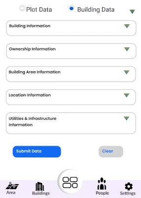
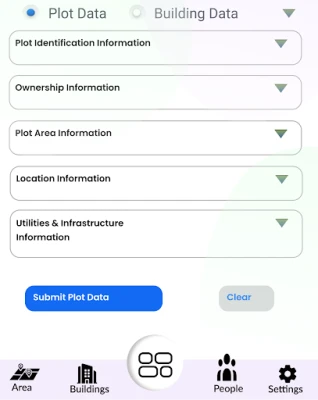
🏢 Site, Asset & Infrastructure Tracking
Manage details related to buildings, sites, utilities, assets, or ongoing projects using structured data entries and map-linked records.
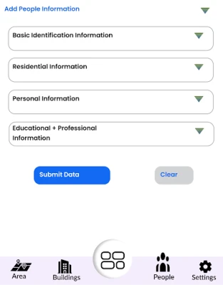
👥 Custom Data Profiles
Create and maintain your own datasets—such as household listings, team assignments, survey entries, or project-specific categories.
🔒 Secure & Private
Your information is encrypted and stored safely. You have full control over the data you create, upload, or manage within the app.
📊 Analytics & Reporting
Generate dashboards, reports, and visual insights to support planning, research, or field operations.
☁️ Cloud-Synced Access
Access your data across devices with seamless synchronization, ensuring your maps and records are always up to date.
🚀 Why MapExplorer?
MapExplorer is built for users who rely on accurate, structured, and visual data—but don’t want complex or expensive GIS systems. The platform is simple, fast, and adaptable to any field that requires mapping and data collection.
⭐ Key Features
🗺️ Interactive Mapping
Explore customizable map layers that help you understand locations, structures, boundaries, and field data with clear visual context.
📍 Field Data Capture
Record location details directly from the field using GPS-enabled tools. Add notes, images, and custom attributes to enrich your dataset.
🏢 Site, Asset & Infrastructure Tracking
Manage details related to buildings, sites, utilities, assets, or ongoing projects using structured data entries and map-linked records.
👥 Custom Data Profiles
Create and maintain your own datasets—such as household listings, team assignments, survey entries, or project-specific categories.
🔒 Secure & Private
Your information is encrypted and stored safely. You have full control over the data you create, upload, or manage within the app.
📊 Analytics & Reporting
Generate dashboards, reports, and visual insights to support planning, research, or field operations.
☁️ Cloud-Synced Access
Access your data across devices with seamless synchronization, ensuring your maps and records are always up to date.
🚀 Why MapExplorer?
MapExplorer is built for users who rely on accurate, structured, and visual data—but don’t want complex or expensive GIS systems. The platform is simple, fast, and adaptable to any field that requires mapping and data collection.
Rate the App
Add Comment & Review
User Reviews
Based on 0 reviews
No reviews added yet.
Comments will not be approved to be posted if they are SPAM, abusive, off-topic, use profanity, contain a personal attack, or promote hate of any kind.


More »

Popular Apps

Smart Teacher: Class ManagerKickstart Coders Ltd

YouTube MusicGoogle LLC

WATI - Team Inbox for WhatsAppClare.AI

Cherrygramunn::ars X

Google CalendarGoogle LLC

MWT: Tank Battles. Modern War5v5 Military Vehicle Shooter

TelegramTelegram FZ-LLC

Metalstorm: Fighter Jet GameBattle in Epic 5v5 PvP Combat

Special Agent CyberDuckLuke Henning

WhatsApp BusinessWhatsApp LLC
 Games
Games Social & Communication
 Tools
Tools Entertainment
 Education
 Music & Audio
 Photo & Video
 Productivity
 Shopping
 Finance
 Health & Fitness
 Travel & Navigation
 News & Magazines
 Books & Comics
 Personalization
 Lifestyle
 Family & Kids
 Food & Drink
 Auto & Vehicles
 Weather